
Tourism in Jammu & Kashmir
Jammu and Kashmir is a union territory of India locked in Himalayan Mountains. Jammu and Kashmir is home to several Valleys such as the Kashmir Valley, Chenab Valley, Sindh Valley and Lidder Valley. Some major tourist attractions in Jammu and Kashmir are Srinagar, the Mughal Gardens, Gulmarg, Pahalgam, Patnitop, sanasar, mansar, surinsar, bhaderwah, akhnoor and Jammu. Some areas require a special permit for non-Indians to visit.
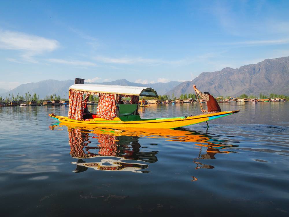
Srinagar

It is the largest city and the summer capital of the Indian union territory of Jammu and Kashmir. It lies in the Kashmir Valley on the banks of the Jhelum River, a tributary of the Indus, and Dal and Anchar lakes. The city is known for its natural environment, gardens, waterfronts and houseboats. It is also known for traditional Kashmiri handicrafts like Kashmir shawls and also dried fruits. It is the northernmost city of India with over one million people.
Srinagar has a humid subtropical climate. The valley is surrounded by the Himalayas on all sides. Winters are cool, with daytime temperature averaging to 2.5 °C (36.5 °F), and drops below freezing point at night. Moderate to heavy snowfall occurs in winter and the highway connecting Srinagar with the rest of India faces frequent blockades due to icy roads and avalanches. Summers are warm with a July daytime average of 24.1 °C (75.4 °F). The average annual rainfall is around 720 millimetres (28 in). Spring is the wettest season while autumn is the driest. The highest temperature reliably recorded is 39.5 °C (103.1 °F) and the lowest is −20.0 °C (−4.0 °F).
Gulmarg

It is a town, a hill station, a popular skiing destination and a notified area committee in the Baramulla district of the Indian administered union territory of Jammu and Kashmir. The town is situated in the Pir Panjal Range in the western Himalayas.
Gulmarg is the “heartland of winter sports in India” and was rated as Asia’s seventh best ski destination. The town is accessible from Srinagar by road via Tangmarg. The road climbs uphill in the last 12 kilometres to Gulmarg passing through forests of pine and fir. Winter sports like skiing, tobogganing, snowboarding and heli-skiing take place on the slopes of Mount Apharwat reachable by a Gondola lift.
Due to its high elevation, Gulmarg has a humid continental climate where the wet winter season sees heavy snowfall, especially for its latitude. Summers are moderate in temperature and length, whereas shoulder seasons are relatively cool.
Leh

It is the joint capital and largest town of the union territory of Ladakh in India. Leh, located in the Leh district, was also the historical capital of the Himalayan kingdom of Ladakh, the seat of which was in the Leh Palace, the former mansion of the royal family of Ladakh, built in the same style and about the same time as the Potala Palace in Tibet. Leh is at an altitude of 3,524 metres (11,562 ft), and is connected via National Highway 1 to Srinagar in the southwest and to Manali in the south via the Leh-Manali Highway.
Leh is the largest province in Jammu and Kashmir, covering approximately 60,000 square miles. It is surrounded by the highest mountain ranges in the world. The region is blessed with beautiful landscapes, sky-kissing monuments, tranquil lakes and evergreen forests which cast a magical scenic beauty. Apart from that, a Leh tour offers the tourists plenty of recreational and adventurous activities like hiking, trekking, river rafting, polo and archery to get engrossed with.
The region is surrounded by the alpine desert and beautiful landscapes. The dry barren landscape of Leh is full of historic Buddhist monasteries which gives it an incredible sight to behold. Leh’s Buddhist monasteries and historical monuments are the main attractions for the visitors. The most imposing and must visit place in Leh is the Leh Palace, which is a nine multistory residence used to be occupied by the royals in the seventh century. The wooden balconies of the Palace truly fill the heart of an individual with pleasure and joy.
Leh has a cold desert climate with long, cold winters from late November to early March, with minimum temperatures well below freezing for most of the winter. The city gets occasional snowfall during winter. The weather in the remaining months is generally fine and warm during the day. Average annual rainfall is only 102 mm (4.02 inches). In 2010 the city experienced flash floods which killed more than 100 people.
Kargil

It is a town in Kargil district and the joint capital of the Indian administered Province of Ladakh. Kargil is the second largest town in Ladakh after Leh. It is located 60 km and 204 km from Drass and Srinagar to the west respectively, 234 km from Leh to the east, 240 km from Padum to the southeast and 1,047 km from Delhi to the south. Kargil was the location of centre at the time of Ladakh wazarat till 1979 which consists of 3 prominent places that are Skardu, Kargil and Leh.
The trade and transit center of the Pan-Asian trade network is situated at an altitude as high as 2,704 m. The wonderful valley with its amazing apricots is a dream destination. Though today Kargil is the second largest urban center of Ladakh it was the gateway for caravans of silk, brocade, carpets, felts, tea, poppy, ivory et al to China, Tibet, Yarkand and Kashmir in the past.
Pahalgam

It is a tourist town and a notified area committee in Anantnag district of the Indian union territory of Jammu and Kashmir. It is a popular tourist destination and hill station. Its lush green meadows and pristine waters attract thousands of tourists from all over the world each year. It is located 45 kilometres from Anantnag on the banks of Lidder River at an altitude of 7,200 feet. Pahalgam is the headquarters of one of the five tehsils of Anantnag district. Pahalgam is associated with the annual Amarnath Yatra. Chandanwari, located 16 kilometres from Pahalgam is the starting point of the yatra that takes place every year in the months of July–August.
Kolohoi Glacier, situated up the Lidder Valley, just below Kolhoi Peak is currently a hanging glacier. It is accessible from Pahalgam via Aru and is known to have extended for at least 35 kilometres. According to the mountaineers from Jawahar Institute of Mountaineering, in 2008, the glacier receded by half since 1985 and it is not safe to study because it is hollow and has 200-foot-deep crevices. Betaab Valley is a valley located 15 kilometres from Pahalgam. The valley got its name from a Bollywood movie Betaab that was shot here. Sheikhpora is a small hill village located on Apple valley Road adjacent to sallar. The village is famous picnic spot, because of its breathtaking scenic beauty and surrounding panoramic view, where one can have an eye on the Holy Shrine of Aishmuqam. are the major attractions of Pahalgam
Pahalgam has temperate climate with long and cold winter and short and mild summer.


